
FileLegit Windows Internet & Network Download Managers Google Satellite Maps Downloader
Google Satellite Maps Downloader logo

Google Satellite Maps Downloader 8.419

  • User Rating:
    ★★★★★
    ★★★★★
    0.0 ★ 0Votes
  • Requirements:
    Windows
  • Version: 8.419
  • Latest updated: 3 weeks ago
  • License: Free Trial  
  • Publisher: AllmapSoft
  • Size: 18 MB
× app stores

Google Satellite Maps Downloader is a Windows utility designed to download satellite map tiles from Google Maps and save them locally for offline use. Instead of capturing a single large image, the software downloads individual map tiles that can later be viewed, combined into larger maps, or exported for use with GIS applications. The downloaded maps can be opened using the built-in Map Viewer or merged into larger image formats such as BMP, JPG, TIFF, PNG, ECW, SGI, IMG, and KMZ. The software also supports exporting map data to SQLite databases, making it compatible with various mapping applications.

For users working with offline navigation, GIS projects, or satellite imagery, Google Satellite Maps Downloader offers a practical way to organize and access downloaded map data without requiring an internet connection.

Features of Google Satellite Maps Downloader

  • Download satellite map tiles from Google Maps
  • Save downloaded tiles locally for offline access
  • Built-in Map Viewer for viewing downloaded maps
  • Combine map tiles into larger maps
  • Export maps in multiple formats, including:
    • BMP
    • JPG
    • TIFF
    • PNG
    • ECW
    • SGI
    • IMG
    • KMZ
  • Export downloaded maps to SQLite databases
  • Compatible with GIS software such as Global Mapper, QGIS, and TatukGIS
  • SQLite databases can be used with mapping applications including RMaps, Locus Map, OruxMaps, and MapBox
  • Proxy server support
  • Displays latitude and longitude information for downloaded tiles

Interface and Usability

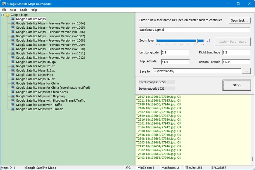
Google Satellite Maps Downloader features a simple interface designed around map downloading rather than visual appearance. Users define the target area by entering coordinates and selecting a zoom level before downloading the required satellite tiles.

Once downloaded, maps can be viewed immediately using the integrated Map Viewer or combined into larger images using the built-in tools. The workflow is straightforward and suitable for users familiar with mapping software, although first-time users may need to understand concepts such as map tiles and zoom levels. The software focuses on efficiency, making it easy to organize downloaded projects and export them for use in other mapping applications.

Who Should Use Google Satellite Maps Downloader?

  • GIS professionals
  • Surveyors and planners
  • Researchers working with satellite imagery
  • Outdoor enthusiasts needing offline satellite maps
  • Developers using offline mapping applications
  • Users who regularly work with Google satellite imagery

Conclusion

Google Satellite Maps Downloader is a specialized tool for users who need offline access to Google satellite imagery. Its ability to download map tiles, merge them into large maps, export multiple image formats, and integrate with GIS software makes it suitable for professional and personal mapping projects.

Pros & Cons

✓

Pros

  • Downloads Google satellite map tiles for offline use
  • Supports numerous export image formats
  • Built-in offline Map Viewer
  • Compatible with popular GIS software
  • SQLite export for mobile mapping applications
  • Proxy server support
  • Displays tile coordinate information
✕

Cons

  • Trial version limits maximum zoom level to 13
  • Advanced zoom levels require the registered version
  • Interface is functional but dated
  • Focused specifically on satellite imagery rather than multiple map providers

Frequently Asked Questions

What is Google Satellite Maps Downloader used for?

Google Satellite Maps Downloader is used to download satellite map tiles from Google Maps so they can be viewed offline, combined into larger maps, or used in GIS and mapping applications.

Can I use downloaded maps without an internet connection?

Yes. Once downloaded, the maps are stored on your computer and can be viewed offline using the built-in Map Viewer or exported for use in compatible software.

Which file formats can Google Satellite Maps Downloader export?

The software supports exporting combined maps as BMP, JPG, TIFF, PNG, ECW, SGI, IMG, and KMZ files. It can also export map data to SQLite databases.

Is Google Satellite Maps Downloader compatible with GIS software?

Yes. Downloaded maps can be used with GIS applications such as Global Mapper, QGIS, and TatukGIS. SQLite exports are also compatible with apps like RMaps, Locus Map, OruxMaps, and MapBox.

Does the software support proxy connections?

Yes. Google Satellite Maps Downloader includes proxy server support for users who connect to the internet through a proxy.

Does the trial version have any limitations?

Yes. According to the developer, the trial version supports downloads up to zoom level 13, while the registered version supports zoom levels up to 21. The actual maximum available zoom may vary depending on the map area.

Recommended apps [Freeware]:
  • AOMEI Backupper 8.4.0 AOMEI Backupper logo easy-to-use Windows backup software for system imaging, disk cloning, and file restoration
  • Futuremark SystemInfo 5.92.1497 Futuremark SystemInfo logo scans your PC hardware and system components, generating detailed diagnostic reports.
  • Stellarium 26.2 Stellarium logo 3D planetarium software showing stars, constellations, planets, and deep-sky objects in real time.
  • Jailer 17.2 Jailer logo database subsetting and data browsing tool for exporting consistent relational datasets and navigating database relationships
  • FotoSketcher 4.40 FotoSketcher logo Transform photos into artistic sketches with creative effects, drawing styles, filters, and simple image editing tools.
  • Godot Game Engine 4.7.1 Godot Game Engine logo Build 2D and 3D games with a free, open-source engine featuring a visual editor, scene system, and cross-platform export tools.
Recommended apps [Shareware]:
  • Gilisoft SnapID 8.8.0 Gilisoft SnapID logo Edit, enhance, retouch, and transform images with powerful tools in Gilisoft SnapID for Windows
  • Bulk Image Downloader 6.64 Bulk Image Downloader logo Download full-size images and videos from galleries, forums, and image hosts with Bulk Image Downloader
  • NTLite 2026.07.11258 NTLite logo Windows customization tool for removing components, integrating drivers, and creating optimized Windows installation images
  • CyberLink PhotoDirector 2026 v17.6.1826.0 CyberLink PhotoDirector logo Edit, retouch, and enhance photos with CyberLink PhotoDirector, featuring AI tools, layer editing, and professional effects
  • UnHackMe 18.50.2026.708 UnHackMe logo Detect and remove rootkits, spyware, Trojans, and hidden malware with a security tool designed to protect your computer.
  • iTop Data Recovery 6.3.0.955 iTop Data Recovery logo Recover deleted files from drives, SSDs, USB devices, and memory cards with a simple Windows data recovery tool.